The shift to 15-minute cities isn’t about banning cars; it’s a data-driven re-engineering of urban space for economic efficiency, and your property’s value depends on understanding this transition.
- Data from over 100 cities shows that well-designed, pedestrian-friendly streets consistently boost local retail sales, rather than harm them.
- New high-capacity transport, like the Elizabeth Line, creates a measurable “connectivity premium” that can add significant value to properties in connected areas.
Recommendation: Instead of fighting the inevitable shift, learn the data behind it to either capitalize on the property uplift or formulate a planning objection that authorities are legally required to consider.
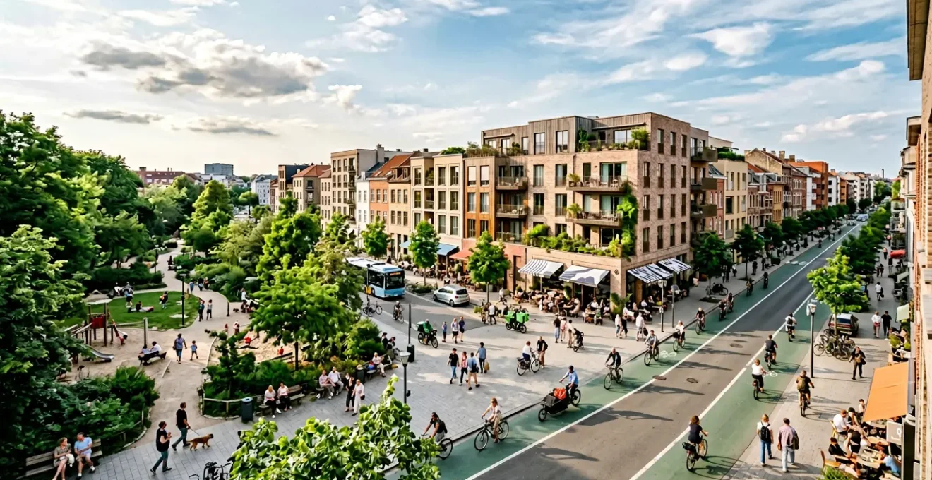
A letter arrives from the local council. New bollards appear at the end of your street overnight. Suddenly, a journey that took five minutes by car now involves a convoluted diversion. For many UK homeowners, this is the first unsettling taste of the “15-minute city” or the “low traffic neighbourhood” (LTN). The immediate reaction is often one of anxiety, framed by headlines about a “war on cars” and fears that these changes will kill local high streets and diminish property values.
These concerns are understandable, but they are based on viewing our streets through a 20th-century lens. From an urban planner’s perspective, this transformation is not an attack on personal freedom but a calculated investment in urban efficiency and economic vibrancy. The debate shouldn’t be about being “pro-car” or “anti-car.” It should be about the most productive use of a scarce and valuable asset: public space. The real question that determines your property’s future value isn’t “Can I park outside my house?” but a much more critical one: “How many people can this street move per hour?”
This article will dissect the core mechanisms driving these changes, grounded in data and property realities. We will analyze the efficiency of different transport infrastructures, debunk the persistent myths surrounding pedestrianisation, explore the real-world impact of major projects like the Elizabeth Line, and provide a practical framework for engaging with the planning process. By understanding the ‘why’ behind the changes, you can better navigate their impact on your most significant asset.
To navigate these complex changes, it’s crucial to understand the individual components that shape this new urban landscape. This article breaks down the key issues, from transport efficiency to economic impact, providing a clear overview of how each element influences property value.
Summary: The Homeowner’s Guide to Urban Transformation and Property Value
- Why closing side roads to cars actually increases footfall for local high streets?
- Bus lanes or Cycle tracks: Which infrastructure investment moves more people per hour?
- How to write a planning objection based on material considerations, not just “I don’t like it”?
- The misconception that pedestrianization kills shops when data shows the opposite
- When to sell a second car: The implementation stage where owning two vehicles becomes a burden?
- Why property prices within 10 minutes of Elizabeth Line stations command a 20% premium?
- Why a £200/month coworking membership is actually cheaper than a season ticket?
- Elizabeth Line vs The Tube: Which Route Offers the Best Property Investment Potential?
Why closing side roads to cars actually increases footfall for local high streets?
The idea that reducing car access can boost a high street seems deeply counter-intuitive. For decades, planning has equated accessibility with ample parking and direct driving routes. However, this conflates two very different functions of a street: a ‘thoroughfare’ for transit and a ‘destination’ for commerce and community. A road clogged with rat-running traffic is an efficient corridor for cars but a hostile environment for people.
When you close a side road or filter traffic, you transform the space from a mere hallway into a potential living room. The reduction in noise, pollution, and physical danger makes the area more pleasant. People feel safer allowing children to walk, they can hold a conversation without shouting over engines, and the air is cleaner. This improved environment encourages people to slow down, linger, and browse. It’s this ‘lingering’ that translates directly into increased economic activity.
A person driving past a shop at 20 mph is not a customer. A person walking past is a potential customer for every single storefront they see. By prioritizing the pedestrian and cyclist experience, you create an environment where local residents are more likely to stay local for their daily needs. This shift cultivates a higher value density, where the economic output per square meter of public space increases dramatically. The street’s value is no longer measured by the number of vehicles it can handle, but by the quality of human experience and commerce it can support.
Bus lanes or Cycle tracks: Which infrastructure investment moves more people per hour?
To understand the logic behind reallocating road space, we must shift our focus from moving vehicles to moving people. An urban planner’s primary metric for efficiency is “person-throughput.” A standard traffic lane might feel busy, but in terms of moving people, it’s often the least efficient use of space. The key question is: what is the highest and best use of a 10-foot-wide strip of asphalt in a dense urban area?
The data provides a clear, and often surprising, answer. A dedicated bus lane, for example, can move between 4,000 to 8,000 people per hour, according to estimates. A single car, even with a passenger, moves just two people. To see how these options stack up, a direct comparison of their capacity reveals the stark difference in spatial efficiency.
The following data highlights the sheer inefficiency of dedicating prime urban space to single-occupancy vehicles. An analysis of different infrastructures shows that options prioritising mass transit or cycling are orders of magnitude more effective.
| Infrastructure Type | Capacity (people/hour) | Width Required | Efficiency per Meter |
|---|---|---|---|
| General Traffic Lane (25 mph) | 1,440 people | 10 feet | Baseline |
| Parking Lane | 792 people | 10 feet | Lowest |
| Cycle Lanes (dual) | 5,200+ people | 6.6 feet total | 164-239% of car lane per meter |
| Dedicated Bus Lane | 6,000 people (50 buses) | 10 feet | 4x general traffic |
| Bus Lane (peak capacity) | 7,440 people | 10 feet | Highest volume |
As the table demonstrates, a dedicated bus lane can be over four times more efficient at moving people than a general traffic lane. Even a pair of cycle lanes vastly outperforms a lane of cars. From a purely logistical standpoint, reallocating a lane from general traffic to a bus or cycle track isn’t a ‘war on cars’; it’s a strategic upgrade to a more efficient system, maximizing the return on the city’s most valuable asset: its land.
How to write a planning objection based on material considerations, not just “I don’t like it”?
When a new traffic scheme is proposed, the natural instinct for those who oppose it is to focus on personal inconvenience. Objections like “It will make my journey longer” or simply “I don’t like it” are emotionally valid but hold zero weight in the formal planning process. To be effective, an objection must be based on ‘material planning considerations’—a specific set of criteria that planning authorities are legally obligated to take into account.
Voicing a generic complaint is a wasted opportunity. To influence a decision, you must speak the language of planners and policymakers. This means moving away from anecdotal evidence and toward objective, evidence-based arguments that address the scheme’s potential failures in relation to established planning policies. An objection grounded in material considerations demonstrates that you have engaged with the proposal seriously and forces the council to provide a considered response.
Instead of simply stating your opposition, you can construct a powerful argument by focusing on quantifiable impacts. The following checklist outlines how to frame your points as material considerations, transforming a personal grievance into a valid planning challenge that demands a formal, evidence-backed answer.
Your Action Plan: Building a Material Consideration-Based Objection
- Person carrying capacity: Demonstrate with data that the proposed infrastructure fails to carry as many people as the adjacent lane, challenging its efficiency.
- Level-of-service analysis: Provide evidence (such as traffic modelling) that the proposal will degrade the roadway’s Level-of-Service to an unacceptable level (below ‘D’).
- Mode shift impact: Quantify the number of drivers who would need to switch to public transport to justify the change, and question if this is a realistic projection.
- Emergency access protocols: Demand specific data or simulations proving that emergency vehicle access times will not be negatively impacted by the new layout.
- Temporal impact assessment: Analyze how the proposal affects traffic differently during peak vs. off-peak hours and question the justification for all-day restrictions.
The misconception that pedestrianization kills shops when data shows the opposite
Perhaps the most persistent and emotionally charged objection to reducing car traffic is the claim that it will destroy local businesses. The image of a high street with empty parking spaces is often equated with a high street of empty shops. This belief, however, is one of the great myths of modern urban planning, consistently debunked by data from around the world.
Extensive research tells a remarkably consistent story: when streets are designed for people instead of cars, businesses thrive. A comprehensive multi-city study revealed that well-implemented pedestrianisation schemes can lead to a significant uplift in trade, with one review showing retail sales increasing by up to 49%. This happens because the nature of the customer base changes. While drivers passing through are a captive audience for billboards, they are not for local shops. Pedestrians and cyclists, on the other hand, are immersed in their environment and far more likely to make impulse buys.
The reason for this success is not a mystery. It lies in understanding what types of businesses benefit most from a pleasant, walkable environment. As researchers who studied the economic impact of pedestrianisation in Spanish cities noted:
The largest positive effect was observed for cafes, restaurants, bars, and other non-tradeable, local consumption activities
– Spanish Cities Pedestrianization Research Team, Economic Impact of Street Pedestrianization Study
In short, pedestrianisation creates an environment that encourages people to linger, socialise, and spend money on experiences. It turns the high street from a transactional corridor into a social destination. While a small number of businesses reliant on bulk-buy car journeys might be impacted, the overall economic health of the area is overwhelmingly positive, creating more value and vibrancy which, in turn, supports property prices.
When to sell a second car: The implementation stage where owning two vehicles becomes a burden?
For many households, the two-car driveway has long been a symbol of suburban success. In the emerging 15-minute city, however, it can quickly become a significant financial and logistical liability. There isn’t a single ‘day’ when this happens; rather, it’s a gradual ‘tipping point’ reached as the urban environment is reshaped around new priorities. Selling a second car becomes the logical choice when the frictional cost of ownership surpasses its convenience.
This friction builds from multiple directions. First, parking space is reclaimed for more productive uses. What was once free on-street parking becomes a paid-for resident’s bay, then a cycle hangar, a parklet, or a wider pavement. The introduction of new Controlled Parking Zones (CPZs) adds a direct annual cost. Second, routes become less direct. Low traffic neighbourhoods are designed to make driving short distances inconvenient, nudging people towards walking or cycling. A five-minute drive can become a fifteen-minute crawl through designated routes.
Finally, direct financial penalties accumulate. Clean Air Zone (CAZ) or Ultra Low Emission Zone (ULEZ) charges can make owning an older second car prohibitively expensive. This combination of shrinking space, increasing inconvenience, and rising costs systematically undermines the value proposition of a second vehicle. The decision is often crystallised by the parallel improvement in alternatives: a new bus route becomes more reliable, a segregated cycle lane feels safer, or a car club bay appears at the end of the street. The moment to sell is when you find yourself planning your life around the car’s limitations, not the other way around.
Key Takeaways
- Urban space is being re-optimised for “people per hour,” a metric where public transport and cycling vastly outperform private cars.
- Data consistently shows that pedestrian-friendly changes boost local economies by increasing footfall and sales for hospitality and retail businesses.
- Major transport upgrades like the Elizabeth Line create a quantifiable “connectivity premium” that significantly outpaces average property growth.
Why property prices within 10 minutes of Elizabeth Line stations command a 20% premium?
The “Crossrail effect” was predicted long before the Elizabeth Line’s purple livery graced London’s transport map. But the reality has, in some cases, exceeded expectations. This isn’t just about a new tube line; it’s about a fundamental re-drawing of the city’s mental map of time and distance. A 20% price premium for properties within a ten-minute walk of a station is merely the average; in the best-performing areas, the impact has been transformative.
Indeed, analysis shows that property price growth has reached up to 150% around certain stations since the project was announced. This surge isn’t just a ripple effect from an overheated market; it’s a direct consequence of creating a high-capacity, high-speed connection that fundamentally alters a location’s investment profile. What was once considered the deep periphery is suddenly within a commutable distance of central London’s high-paying jobs.
The ‘connectivity premium’ is a direct boost to property values, a tangible reward for proximity to this new infrastructure. A prime example of this phenomenon can be seen in an outer London borough that was previously considered one of its least connected.
Case Study: The Havering Borough Transformation
Havering, one of London’s most affordable boroughs, defied the wider market slowdown with an 11% house price rise in the 12 months following the Elizabeth Line opening in May 2022. The opening of three Elizabeth Line stations (Romford, Gidea Park, and Harold Wood) connected the borough to central London in under 30 minutes, with median prices rising from £417,000 to £462,000. Bloomberg’s analysis of UK Land Registry data revealed this was the only double-digit percentage growth in London during that period, demonstrating the transformative impact of improved transit connectivity on previously isolated areas.
Why a £200/month coworking membership is actually cheaper than a season ticket?
The financial calculus of the daily commute has been upended by the twin forces of hybrid working and major transport investment. On the surface, comparing a £200 monthly coworking fee to a £230+ monthly season ticket seems like a simple cost-saving exercise. However, the true equation is far more complex, especially in the context of areas transformed by projects like the Elizabeth Line.
First, the “privilege” of living near these new transit hubs comes at a steep and rising cost. The desirability of these locations has pushed up rental values significantly. In fact, research analysing over 80,000 homes found a 31% surge in rents near Elizabeth Line stations since its opening. This increase in the basic cost of living near the station must be factored into any financial calculation about commuting.
When you weigh the options, the season ticket represents more than just its face value. It represents two hours of unpaid time per day, the high cost of a city-centre lunch, and the associated stress. The £200 coworking membership, by contrast, buys back that time. It anchors your spending in your local community—supporting the very cafes and shops that benefit from pedestrian-friendly policies. It fosters a better work-life balance and reduces the strain on both your wallet and your wellbeing. For a household already paying a premium to live in a well-connected area, paying again to leave it every day makes increasingly little financial sense. The coworking space, in this new reality, isn’t just a desk; it’s an investment in a more efficient and sustainable lifestyle.
Elizabeth Line vs The Tube: Which Route Offers the Best Property Investment Potential?
For a property investor or a homeowner thinking about long-term value, not all transport links are created equal. The London Underground, or ‘The Tube’, represents a mature, stable, and fully-priced network. Proximity to a Tube station is a known and established asset. The Elizabeth Line, however, represents a different kind of opportunity: a step-change in connectivity whose full potential is still being priced into the market.
The headline figures are compelling. On average, property research reveals that the average Elizabeth Line property is worth 54% more than the national average. But the crucial question for an investor is about future growth, not just current value. Is it better to buy into the proven stability of the Tube network or the dynamic potential of the Elizabeth Line? A comparative analysis by property experts breaks down the key differences for investors.
| Investment Metric | Elizabeth Line (New Infrastructure) | Established Tube Lines |
|---|---|---|
| Property Value Growth Since Construction | 52% (2009-2022) | ~30% national average |
| Stations Showing Value Uplift | Only 1/3 before opening | Mature pricing already factored |
| Journey Time Reduction | 11-19 minutes to central London | Minimal improvement |
| Investor Profile Match | Value Growth Investors (long-term appreciation) | Yield Investors (stable rental returns) |
| Future Potential | High – connectivity now reality | Limited – already established |
| Risk Profile | Resilient multi-hub connectivity | Single CBD dependency risk |
The data from Savills clearly shows two distinct investment profiles. The established Tube network is ideal for a ‘Yield Investor’ seeking stable, predictable rental returns in a mature market. The Elizabeth Line, on the other hand, is the domain of the ‘Value Growth Investor’, one who bets on the long-term appreciation driven by transformative infrastructure. It offers higher potential for capital growth because it is fundamentally reshaping how and where people choose to live and work across the capital.
By understanding these urban planning principles, you are no longer a passive observer of change but an informed stakeholder. You can now analyze your own area’s plans, assess the impact on your property’s value, and decide whether to capitalize on the change or challenge it with evidence. The next step is to look up your local council’s development plan and see where your property fits into this new urban map.